Official Map City of St. Louis – folded
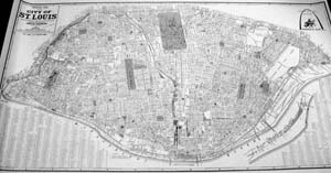
If you need a detailed scale map of the City of St. Louis showing every city block (with its city block number) and dozens of other details, you will want this large map in your collection. At a scale of 1,320 feet to one inch and measuring approximately 30 inches by 55 inches, the map covers the entire city area of 61.37 square miles. Reproduced in black and white, the map is clear, sharp, and includes a street index at the bottom. St. Louis building permits and property deeds contain the city block number. Regardless of street name changes, those city block numbers stay the same. This means that if you are doing a search for a piece of property or if you are working on the history of a piece of property, the map will be of great value to you. This map will ship folded in an envelope. If you would like your map rolled in a mailing tube, please use product BC229b.
Official Map of the City of St. Louis as established by the City Charter of 1876; Published by the Street Department of the City of St. Louis, 2001
$8.00
Out of stock